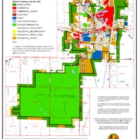
2006 Existing Land Use Map
Dublin Core
Title
2006 Existing Land Use Map
Subject
Existing Land Use Map
Description
This document provides a map of the City of Williston existing land use.
Creator
Withlacoochee Regional Planning Council
Source
Levy County Property Appraiser, Florida Geographic Data Library
Publisher
City of Williston
Date
August 12, 2009
Contributor
[no text]
Rights
This is a public resource funded by federal and state grants.
Relation
[no text]
Format
TIFF
Language
English
Type
Map
Identifier
[no text]
Coverage
City of Williston, Florida geographical boundaries
Files
Collection
Citation
Withlacoochee Regional Planning Council, “2006 Existing Land Use Map,” LIS5472 Sp18 Group 4, accessed February 23, 2026, https://lis5472.cci.fsu.edu/sp18/group4/items/show/17.
